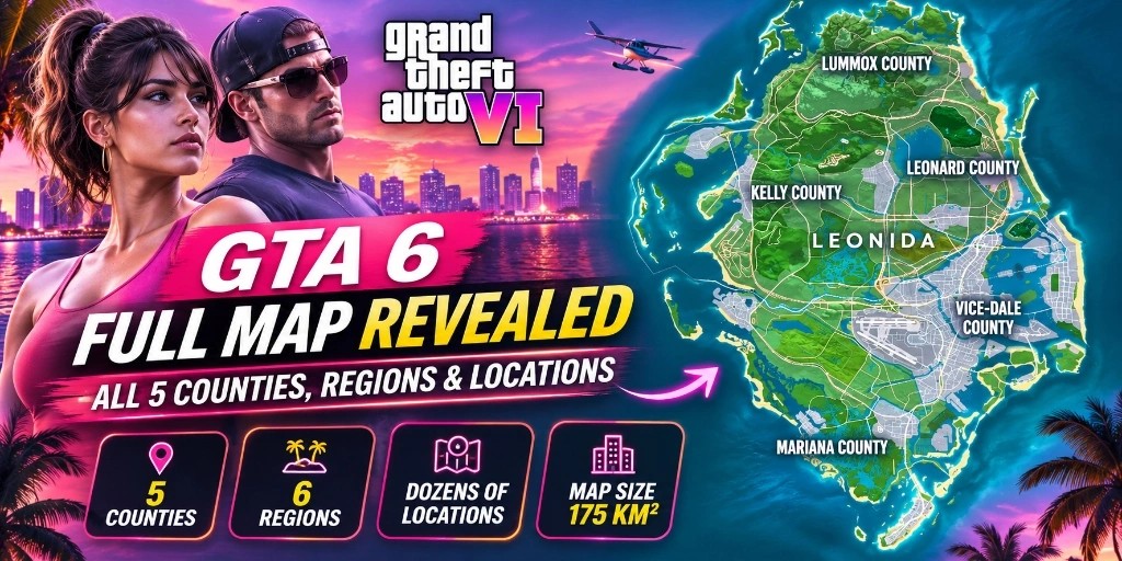
The full Grand Theft Auto VI world map has been revealed, giving players a much clearer look at Leonida, its counties, coastal islands, rural towns, swamps, mountains and the massive urban landscape of Vice City. The newly published in-game map guide from PowerPyx lists five counties and dozens of named locations, revealing just how much of Leonida players will be able to explore.
For players who have been following GTA VI map discoveries since the trailers and early map discussions, this is a major development. Names such as Southwind, Key Lento, Pelican Valley, Moreau, Port Gellhorn and Mount Kalaga are now part of the map's expanded location list.
The map also provides a better understanding of how Vice City connects to the rest of the state. Beyond its downtown skyline and beaches, Leonida contains island chains, wetlands, industrial towns, waterways, lakes, national parks and rural settlements.
According to PowerPyx's map measurements, the GTA VI world covers approximately 175 square kilometres, or 67.5 square miles. The guide estimates that around 65% of the map is land and 35% is water.
In this GTA6Daily map guide, we break down all five county divisions, the named locations within each area, Vice City's neighbourhoods, map activity categories and the locations players should explore first.
We also connect the locations to our interactive Leonida Atlas so you can continue exploring individual areas and their available information.
---
Featured Answer: The GTA 6 Map at a Glance
The GTA 6 map is set in Leonida and includes five county divisions: Mariana, Vice-Dale, Kelly, Leonard and Lummox. Rockstar officially highlights six major destinations: Vice City, Leonida Keys, Grassrivers, Port Gellhorn, Ambrosia and Mount Kalaga National Park.
---
GTA 6 Map: Quick Overview
| Map Information | Details | |
|---|---|---|
| Game | Grand Theft Auto VI | |
| State | Leonida | |
| Main City | Vice City | |
| County Divisions | 5 Official Counties | |
| Official Rockstar Destinations | 6 Major Destinations | |
| Estimated Map Size | 175 km² (67.5 sq mi) | |
| North-South Measurement | Approximately 16 km | |
| East-West Measurement | Approximately 10.9 km | |
| Land Coverage | 65% | |
| Water Coverage | 35% | |
| Playable Protagonists | Jason Duval and Lucia Caminos | |
| Launch Platforms | PlayStation 5 and Xbox Series X | S |
Note: The area and land-water figures are measurements reported by third-party gameplay analysts rather than Rockstar's official technical specifications.
---
GTA 6 World Map: All Five Counties Explained
The newly published in-game map guide identifies five major county divisions across Leonida. Each county contains multiple locations, districts, waterways and geographical features.
Here is the complete county breakdown from the verified location list.
1. Mariana County: Southern Leonida
Mariana County occupies the southern portion of Leonida and contains several coastal and island locations. This section includes the Leonida Keys, multiple bays, wetlands and areas surrounding the southern coastline.
It is one of the most interesting parts of the map for players who enjoy boating, fishing and exploring smaller settlements.
Named locations in Mariana County:
- Mile Zero Air Station: An aviation-related military airfield located near the southern tip of the map.
- Southwind: Coastal settlement along the upper Keys causeway.
- Riquezas Keys: A chain of affluent tropical islands south of Vice City.
- Permit Keys: Fishing and boating island cluster.
- Maroon Key: Outlying key with secluded coves.
- Abismo Key: Deep-water coastal island.
- Leonida Bay: Expansive southern waterway opening to the Atlantic.
- Key Lento: Major island community featuring Jason's safehouse.
- Gambit Bay: Protected harbor popular with smugglers.
- Shoeless Keys: Informal beach shanties and dockside settlements.
- Corsair Key: Historical privateer island.
- Peregrine Bay: Mangrove-sheltered estuary.
- Leonida Straits: Deep navigation channel connecting the Keys to the mainland.
- Pelican Valley (Swamps): Mangrove wilderness home to the Kingfishers gang.
- Cottomouth Lake: Freshwater wetland basin.
- Wetman Bay: Low-lying tidal bay.
- Gullet Marsh: Dense alligator-populated swamp waters.
- Pelican River: Winding river connecting inland marshes to the coast.
- Watson Bay: Quiet residential coastal bay.
- Bobcat Key: Rural key with wildlife habitats.
- Bobcat Bight: Natural inlet along the Keys highway.
- Grassrivers: The massive subtropical wetlands of southern Leonida.
- Tola Bay: Scenic coastal inlet.
- Capri & Capri Sound: Resort island and sheltered sailing sound.
- Tortoise Lake: Natural preserve lake.
- Belpoint: Coastal headland and navigation light.
- Gulf of Leonida: The broad western sea basin.
- North Mariana County & Nehrling River: River gateway separating Mariana from Kelly County.
Explore related GTA6Daily locations: Leonida Keys Atlas | Pelican Valley | Grassrivers Atlas | Goose Key
---
2. Vice-Dale County: Home of Vice City
Vice-Dale County contains the main urban destination of GTA VI, Vice City. This is expected to be one of the busiest areas in the game, with its beaches, neighbourhoods, shopping districts, entertainment venues, ports and road networks.
The map lists several major areas within Vice-Dale County, including the city core and the surrounding districts.
Named locations:
- Hamlet: Suburb northwest of Vice City.
- South Vice-Dale County: Industrial and agricultural fringe.
- VCIA (Vice City International Airport): The primary international airport hub.
- Vice City: The massive urban center.
- West Vice-Dale County: Commercial and residential sprawl.
- Vice Beach: The famous barrier island beach strip.
Vice City districts and sub-locations:
- Southside: Working-class residential neighborhood.
- Peacock Bay: Waterfront marina district.
- Tequesta & Tequesta Retreat: Historic upscale residential community.
- Downtown: Commercial tower skyline and financial core.
- Little Cuba: Vibrant cultural hub filled with diners, music and street life.
- Salton: Mid-city transit corridor.
- Rockridge: Residential district north of downtown.
- Crosstown: Central freeway interchange zone.
- Bayside: Shopping promenade and boardwalk.
- La Perle: High-end boutique neighborhood.
- Balsero: Immigrant quarter with industrial docks.
- Stockyard: Commercial meatpacking and warehouse zone.
- Decor District: Art Deco architectural showpiece.
- Leaf Links: Luxury golf course and gated island estate.
- Rialto Islands: Man-made residential islands.
- Starfish Island: Exclusive celebrity mansion enclave.
- Waxman Island: Waterfront commercial district.
- Port Vice City: Deep-water container cargo port.
- Catalan Bay, Catalan Key & Gloriana Key: East-facing coastal islands.
- Dalton Island: Industrial island near the harbor mouth.
Vice Beach locations:
- Ocean Beach: Iconic pastel Art Deco hotel boulevard and sandy promenade.
- Washington Beach: Wide public sands and lifeguard stands.
- Atlantic Ocean: Open ocean boundary along the eastern shoreline.
Why Vice City is Important
Vice City is the central urban environment in GTA VI. It brings together the game's major commercial, residential and entertainment areas. It also contains many of the businesses, clothing boutiques and mod shops players will visit repeatedly.
Some of the neighbourhoods are particularly important for exploring the city's identity. For example, Downtown features the modern glass-and-steel skyline, while Ocean Beach and Washington Beach represent the coastal side of the city. Little Cuba and the other named districts provide deep storytelling flavor away from the beachfront.
Explore Vice City in the GTA6Daily Atlas:
- Open Vice City Region Guide
- Ocean Beach
- Washington Beach
- Vice City Beach
- Art Deco District
- Downtown Vice City
- Port of Vice City
- Rideout Customs
- Ocean Drive Promenade
---
3. Kelly County: North-West Leonida
Kelly County covers the north-western region of the state. Its map locations include swamps, rivers, coastal areas, islands and Port Gellhorn.
Unlike Vice City, this part of the world focuses more on rural environments, industrial facilities, refineries and smaller working communities.
Named locations:
- South Kelly County: Rural border with Mariana County.
- Buckskin Swamp: Muddy backwaters and hunting grounds.
- Emerald River: Inland river route running from the interior hills.
- Emerald Springs (transcribed as Emerland Springs in some lists): Natural thermal spring and tourist stop.
- Gellhorn & Port Gellhorn: Major western port city with industrial boardwalks.
- Wild Hog Point: Rugged coastal promontory.
- Borrachero Sound: Broad coastal bay.
- Crude Islands: Oil-drilling and refinery islands.
- Sandbars: Shallow tidal shallows ideal for fanboat exploration.
- Draper Island & Draper Bay: Secluded bay communities.
- North Kelly County, Frogswater & Manifest Canyon: Rocky canyons and creekbeds heading toward the northern ridge.
Editorial note on spelling: PowerPyx's world-map list transcribes one entry as "Emerland Springs". Other GTA VI location references use "Emerald Springs". We use Emerald Springs as the normalized name in our editorial tracking, while retaining the alternate spelling for source comparison.
Port Gellhorn: A Major Destination in Western Leonida
Port Gellhorn is one of Rockstar's six officially named destinations. Its working-class coastal setting and industrial boardwalks provide a stark contrast to the neon glow of Vice City. The region is worth exploring for its commercial docks, transit depots, motels and winding backroads.
Explore Kelly County locations:
---
4. Leonard County: North-East Leonida
Leonard County is identified as the north-eastern region of Leonida. Its territory includes extensive coastal shorelines, large inland lakes, protected state forests and quiet agrarian settlements.
Named locations:
- South Leonard County: Highway link leading into Vice-Dale County.
- Belville: Quiet farming community.
- Waning Sands: Pristine coastal sand flats.
- Leith River: Navigable tributary emptying into the lake.
- North Leonard County: Rolling pine scrub country.
- Lake Leonida: The massive freshwater centerpiece of the state.
- Richard Barebone State Park: Protected nature reserve featuring trails and wildlife.
- Little Hardin Island: Scenic island situated inside Lake Leonida.
Waning Sands and Lake Leonida are particularly useful landmarks because they establish the geographical boundary north of Vice City. The presence of Richard Barebone State Park provides a major wildlife observation ground for the 100-animal completion milestone.
---
5. Lummox County: Northern Leonida
Lummox County encompasses much of the northern map and features mountain peaks, river valleys, reservoirs and historic mining towns. This county is particularly exciting for players who enjoy off-road driving, hiking and remote criminal hideouts.
Named locations:
- South West Lummox County: Foothill region.
- Zephyr Islands: Small river island group.
- Mount Kalaga National Park: Towering mountain peak and forest wilderness.
- Grayson: Mountain outpost town.
- San Malo Bay: Rugged northern saltwater bay.
- Featherstone Islands: Secluded coastal island chain.
- Bonanza: Historic mining settlement.
- Okchioha Bay: Deep northern inlet.
- Moreau & Moreau River: Fast-moving whitewater river and logging camp.
- MacAlister Gold Mine: Abandoned subterranean mine works.
- Saint Attaway Islands & Hyde Island: Northernmost island territory.
- East Lummox County, Partridge Bay & Frampton Islands: Northeast shoreline.
- Lake Tallaloko, Kalaga Reservoir & Dawson Dam: Major hydroelectric complex supplying power to Leonida.
- Millport & Millport Basin: Industrial dam settlement and reservoir basin.
Mount Kalaga: Leonida's Northern Wilderness
Mount Kalaga National Park is another of the six major destinations Rockstar officially highlights. It introduces rugged topography, switchback mountain roads, ranger lookouts and whitewater rivers, providing endless opportunities for dirt bikes, ATVs and off-road vehicles.
Explore Mount Kalaga in the GTA6Daily Atlas
---
GTA 6 Map: Five Counties vs Six Official Rockstar Regions
One detail that may confuse players is the difference between the five counties shown on the in-game map and the six destinations highlighted on Rockstar's official website.
They represent two different geographical classifications:
- Counties are internal administrative borders dividing government services, police departments and judicial jurisdictions.
- Rockstar Regions are curated promotional and thematic destinations designed to highlight the diverse biomes of Leonida.
| Official Rockstar Destination | What the Area Represents | Corresponding County |
|---|---|---|
| Vice City | Main urban metropolitan center | Vice-Dale County |
| Leonida Keys | Southern tropical island chain | Mariana County |
| Grassrivers | Subtropical wetlands and sawgrass marshes | Mariana County |
| Port Gellhorn | Western coastal port town and industrial center | Kelly County |
| Ambrosia | Central rural and agricultural heartland | Kelly / Leonard Counties |
| Mount Kalaga National Park | Northern mountainous wilderness and state park | Lummox County |
Explore Rockstar's official media: [Rockstar Games: Only in Leonida]([object Object])
---
How Big Is the GTA 6 Map Compared to Its Geography?
According to gameplay measurements, the GTA 6 map covers approximately 175 square kilometres (67.5 square miles).
| Dimension / Metric | Measurement |
|---|---|
| North to South | 16 km |
| East to West | 10.9 km |
| Total Surface Area | 175 km² (67.5 sq mi) |
| Land Coverage | 65% |
| Water Coverage | 35% |
Why Does the Water Area Matter?
Water represents 35% of Leonida's surface. The extensive network of shallow flats, open seas, deep straits and mangrove rivers creates rich gameplay opportunities for powerboats, fanboats, jet skis, fishing and scuba diving.
Instead of relying solely on interstate highways, players will frequently travel between counties using bridges, ferries, water taxis and seaplanes.
Are GTA 6 Buildings Enterable?
Gameplay guides confirm that a remarkable percentage of buildings feature enterable interiors. While not every storefront is open, convenience stores, diners, bars, gun shops, garages, salons and bank branches are fully walkable. Selected skyscrapers in Downtown Vice City also feature functioning elevators that grant access to multiple floors and penthouses.
---
GTA 6 Map Icons: All Activities, Shops and Business Locations
The revealed map guide documents 23 distinct activity, business and service categories across Leonida.
| Map Category | Total Locations | Gameplay Function |
|---|---|---|
| Gang Operations / Illegal Operations | 39 | Hostile compound raids with cash and weapon rewards |
| Bank Jobs | 22 | 14 small bank branches and 8 large bank vaults |
| Payday Loans | 7 | High-risk fast cash robberies requiring Dye Pack Jammer |
| Smash 'n' Grabs | 35 | Jewelers and pawn shops with backroom safe cracking |
| Mod Shops | 14 | Performance tuning, engine upgrades, rims and tint |
| Pay 'n' Sprays | 19 | Emergency vehicle resprays to lose active police Heat |
| Gas Stations | 57 | Vehicle refueling, tire inflation, snacks and ATMs |
| Car Washes | 6 | Clean mud, blood and dirt off vehicles |
| Ammu-Nations / Gun Stores | 24 | Firearms, ammunition, body armor and weapon attachments |
| Garages | 12 | 8 buyable property garages plus 4 story garages |
| Train Stations | 25 | Rapid rail passenger transit across the metropolitan core |
| Ferry Terminals | 2 | Vehicle and passenger transport to outlying islands |
| Clothing Stores | 67 | Streetwear, high-end suits, beachwear and thrift shops |
| Footwear Stores | 17 | Sneakers, work boots, running shoes and sandals |
| Hair & Beauty Salons | 18 | Barber shops, styling parlours and beard grooming |
| Tattoo Studios | 11 | Custom ink and body art studios |
| Electronics Stores | 15 | Radios, cameras, cell phones and tech supplies |
| Convenience Stores | 72 | 24/7 markets selling Zombix healing items and snacks |
| Fast Food Stores | 21 | Burgers, fried chicken and drive-thru dining |
| Cafes & Takeout | 87 | Coffee shops, juice stands and breakfast counters |
| Liquor Stores | 14 | Bottle shops with backroom safe pickups |
| Bars & Nightclubs | 122 | Nightlife venues, pool tables and dance floors |
| Street Food Vendors | 118 | Quick street food carts and mobile trucks |
---
Explore the GTA 6 World Map With GTA6Daily's Leonida Atlas
GTA6Daily has launched an interactive Leonida Atlas designed to help players navigate the world of Grand Theft Auto VI.
Features of the Leonida Atlas:
- Complete coordinate mapping for verified locations across all 5 counties.
- Live category filters for Bank Jobs, Districts, Landmarks, Businesses, Safehouses and Nature.
- GPS radar target icons with animated pulse indicators and category color coding.
- Fully responsive map viewport that remains locked to geographic landmasses across mobile and desktop displays.
- Dedicated location dossiers with screenshots, lore, and connection to vehicle spawns.
Open the GTA6Daily Interactive Map and start plotting your path across Leonida.
Stay ahead of Vice City.